
Agroforestry along watercourses
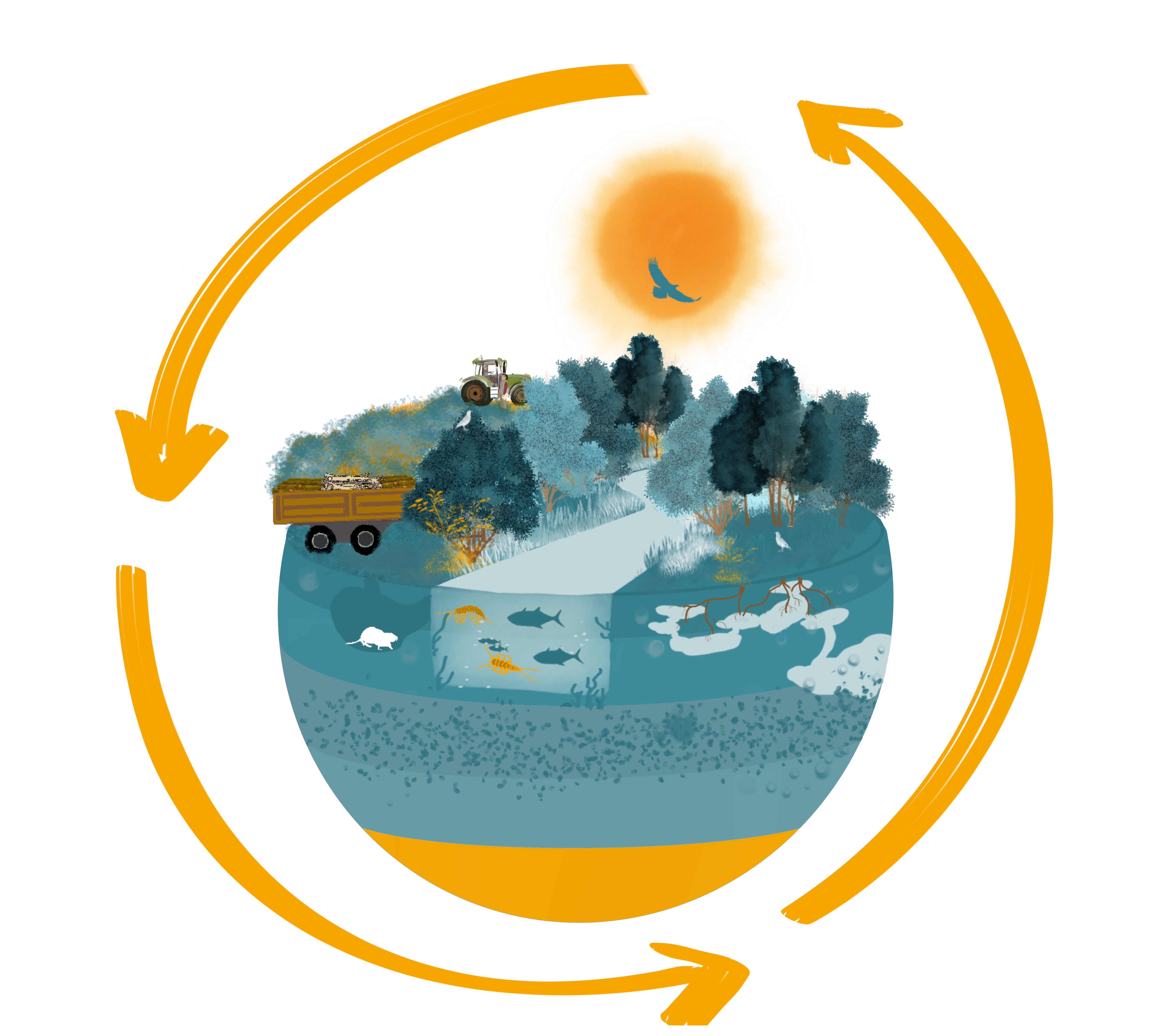
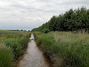
Smaller watercourses are important landscape elements in urban and rural areas. They provide a range of ecosystem services, such as climate regulation, watercourse and flood protection, recreation or biodiversity conservation. According to the EU Water Framework Directive, however, only 6.7% of surface waters are in good condition. OLGA is therefore researching how the ecological condition of small watercourses can be improved by sustainably planting agrowood structures near the banks.
What ecosystem services do agrowood plantations along watercourses provide, especially in terms of watercourse , climate and flood protection and for the protection of biodiversity?
What economic perspectives and marketing opportunities arise here for farmers and landowners and how can agricultural wood be made better known as an agricultural product and energy resource?
The following activities are being carried out within module 1:
- Monitoring of the microclimate of woody streams by means of water level and temperature measurements and the investigation of the existing biological macrozoobenthos in the years 2021, 2022 and 2023
- Modelling the effects of vegetation on flood retention and aquatic habitats using habitat modelling and the development of flood scenarios
- Structural analysis of agricultural woods and visualisation using 3D laser scanning
- Investigation of the plant physiology and rooting of agricultural trees and shrubs in order to gain insights into the development of the microclimate, the water balance and the rooting dynamics of these wood species
- Implementation of an agro-wood plantation in the Dresden region
What role can agroforestry play in the future for the regional and decentralized supply of renewable resources? What possibilities are there for further processing and utilization? Where are there already players in Brandenburg and Saxony who are involved in the value chain?
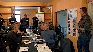
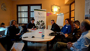
In order to discuss the variety of cooperative relationships between producers and buyers of agricultural timber for the establishment of regional material and value-added cycles, 29 farmers, municipal representatives, entrepreneurs and industry partners interested in agroforestry met with practice-oriented researchers from the AgroWertRegio, Wertvoll and OLGA as well as the German Association for Agroforestry - DeFAF and the Saxon State Office for Agriculture and Geology.
The current strategic plan of the EU's Common Agricultural Policy (CAP) assumes that the area of agroforestry on German fields will be around 200,000 ha by 2026. In December 2023, this figure is currently around 56 ha. So there is still a lot to do: How can we get more agroforestry on the land in the future? To do this, we need courageous and committed farmers, but also - to stay with the wood value chain - municipalities and energy suppliers who buy the wood from farmers and feed it into their local or district heating networks in the form of wood chips.
After introductory presentations on the advantages of agroforestry in general and the legal framework for the establishment and maintenance of agroforestry systems in Brandenburg and Saxony, farmer Thomas Domin and Tobias Peschel from the planting company Lignovis GmbH reported on their practical experience: there are no
limits to the various cultivation/planting formats and the associated diversification of value creation. They are geared towards the environmental conditions at the location and the economic interests of the farm: whether in strips linked to the farm's own crop rotation, over a large area, as a chicken forest or in coexistence with valuable woods and/or shrub crops - the fast-growing tree species planted for wood use, such as poplar or willow, are very frugal. Once they have been planted, they can bind a lot of CO2 on the potentially available land in Germany and lead it into new cycles. What is needed now is creativity, economic diversification and a little optimism and courage!
Two workshop sessions were held to discuss the framework conditions for establishing a regional value chain for wood from agroforestry and possible opportunities for cooperation in establishing systems, maintenance and wood harvesting. Farmers want security in the form of long-term lease agreements with wood purchase guarantees of up to 15 years. For example, Energy Crops GmbH, a subsidiary of Vattenfall AG, concludes such long-term cooperation agreements with agricultural businesses for Berlin's heat supply.
The farmer leases the land and prepares the soil, while Energy Crops assumes the costs and risk for planting, maintenance, harvesting and transportation. In addition to these offers from the industry, a municipality, a local energy company or a cooperative can also work together with agriculture. Thomas Pöge, Mayor of Thallwitz/Wurzener Land, was connected online and explained how multi-use concepts can form the basis for long-term cooperation between municipalities and farmers.
For the future, it is important to clarify that the establishment and use of agroforestry systems is legally regulated by the CAP and that there is nothing to fear if you dare. Agroforestry systems should be understood and communicated as land use systems with numerous advantages and a relatively long lifespan - even beyond the use of wood for energy or material purposes. In addition to the yield benefits, services to promote biodiversity, soil structure and adaptation to climate change play a major role here. With a view to the value chain of wood from agroforestry with fast-growing tree species, municipalities should seek more dialog with their farmers. There is great potential here in terms of a more independent municipal and CO2-neutral heat supply with wood from the field.
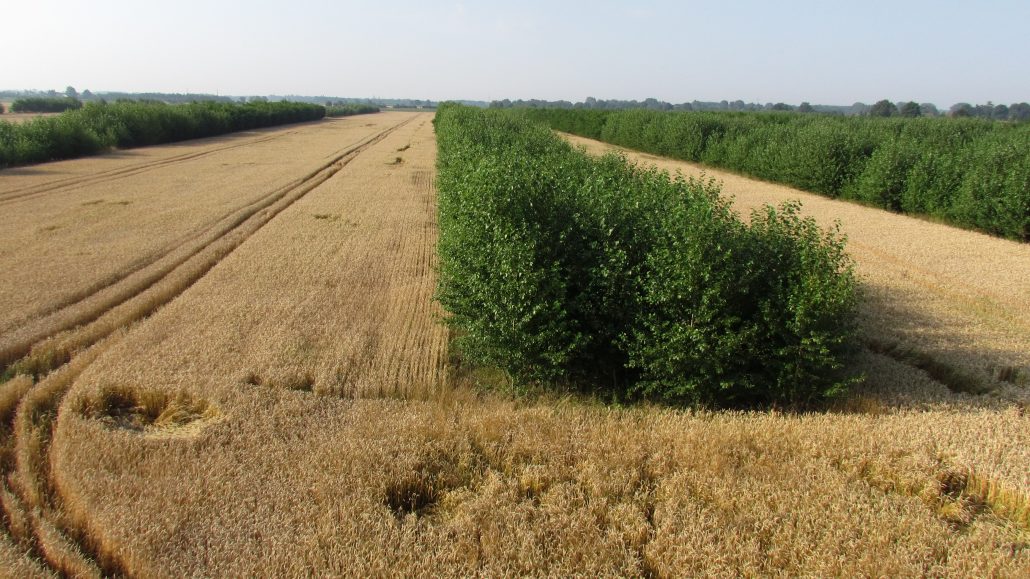
Agroforestry systems with fast-growing tree species coexist with natural woodland and are an enrichment for small watercourses in agricultural areas. Through their shading and cooling effects, they make an important contribution to stabilizing water ecology, especially on hot summer days and during hot spells. In the OLGA project, studies were carried out on two water-accompanying agroforestry systems in the Dresden region to investigate their contribution to climate mitigation on agricultural land. The results of the analyses are presented in this article.

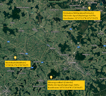
In the OLGA project, studies were carried out on two water-accompanying agroforestry systems in the Dresden region to investigate their contribution to climate mitigation on agricultural land. The graphs in Fig. 1 show the course of the water temperature at the Peickwitzer Mühlgraben near Senftenberg over three summer days. Sensor 1 (S1) describes the water temperature at the beginning of the study area. S2 and S3 are located in the section of the watercourse that is shaded by the approx. 400 m long agricultural wood structure. The shading reduces the water temperature here, while at S4 and S5 in the unshaded area it rises sharply again. With the data evaluated at the Peickwitz site, it can be shown that the shading of bank areas in a stocked section of 350 m length can generate a temperature reduction of up to over 4 °C at low water discharge and up to 1 °C at 70 m of the agroforestry system.
Statistically, the contribution of bank shading was confirmed by a multiple regression analysis when comparing individual stream sections. None of the other meteorological parameters investigated (air temperature, humidity, air pressure or wind speed) had a similarly significant influence on the temperature reduction in the watercourse.
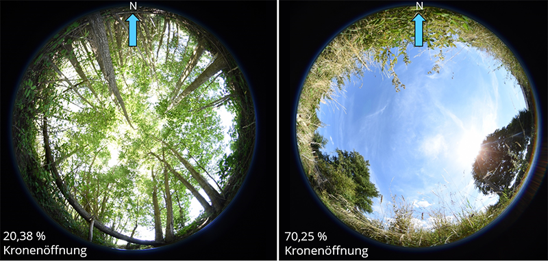
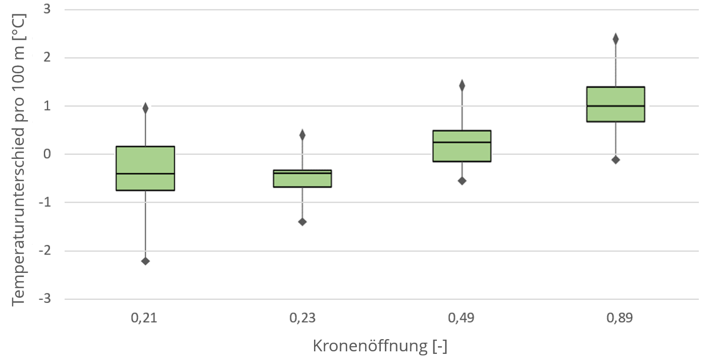
Hemispheric photographs were taken at the second study site, the agricultural wood system at Wiesengrundbach in Colmnitz between Tharandter Wald and Osterzgebirge, to determine the shading effect of the adjacent riparian vegetation (Fig. 2). These special photographs serve to determine the canopy opening and thus the shading characteristics of riparian vegetation, here in particular of agroforestry systems. The agricultural wood structure close to the watercourse (left image in Fig. 2) increases the shading of the riparian vegetation from existing trees, so that the canopy cover can be reduced to an average of approx. 20 %, which also measurably reduces the water temperature locally. Fig. 3 shows the measured temperature change over a flow length of 100 m for areas with different canopy cover. It can be seen that a low canopy opening leads to a temperature reduction in the watercourse, while a high canopy opening causes the temperature to rise by up to 1° C per 100 m.
The hemispheric photos taken also make it possible to determine the heat radiation entering the body of water by determining the path of the sun. The direct and diffuse global radiation under a sunny sky is calculated. This value could be reduced at the Wiesengrundbach in the summer months of May to September 2022 from an average of over 200 watts/m² for unshaded conditions to approx. 48 watts/m² at the Wiesengrundbach due to the bank vegetation. Fig. 4 shows the sun's path during these months at a location with an agricultural wood structure along the watercourse. The photo is divided into black areas (sky) and white areas (vegetation) for evaluation purposes. The path of the sun changes due to the seasonal change in the position of the sun. The lines closest to the center of the image correspond to June 21, 2022.

Temperature and radiation measurements were also carried out at the Peickwitz Mühlgraben to determine the influence of the agricultural wood system on the air temperature. In order to assess the effect of the woodland strip on the ambient temperature of the adjacent areas, radiant heat measurements were carried out using globe thermometers at various locations in the stand and outside the agroforestry structure. Three comparative measurements were carried out at a) the edge of the stand near the water, b) in the grove and c) in the middle of the adjacent harvested arable land. The temperatures show a clear gradation. There was a temperature difference of up to +1.9°C between the inside of the experimental plantation and its edge to the watercourse, and up to +11°C between the inside of the stand and the surrounding harvested arable land.
Terrestrial laser scanning (TLS) is a technology that can use a transmitted laser pulse to represent an environment in detail as a 3D point cloud. Although TLS has only been applied to forests since the 2000s, it offers great potential to measure individual trees down to the smallest branch. This can be used to accurately calculate biomass volumes, among other things. This is hardly possible with manual measurements.
To visualize the agroforestry system at Peickwitz in southern Brandenburg, a 3D flight through the agroforestry system planted with the poplar species Fritzi-Pauley was undertaken. For this purpose, data from the year 2021 recorded by means of TLS were used. A high-resolution point cloud of the then 6-year-old stand was created from a total of 229 individual scans, allowing a detailed representation of the individual trees. The trees were scanned at two different times, once in an unfoliated state (March) and in a foliated state (August).
Especially the data in March was suitable for performing a structural analysis due to the lack of foliage. This allowed each branch to be scanned with the laser. Average tree heights of 12.96 m and breast height diameters of 13.05 cm were measured, suggesting a weight (atro*) of 9.57 t for the stand, or 177.2 t/ha. The measurements may eventually be available for accurate calculations of biomass growth and timber yield. According to the analyses, the biomass potential for the plantation in Peickwitz is estimated to be high.
However, during the second scanning in August, leaves obscured smaller branches, resulting in a less accurate representation of the stand. However, by combining TLS data with photographic images, a more color-accurate visualization of the trees at this time could be achieved.
*atro = absolutely dry
https://youtu.be/4QtqRp124fI
The low discharge values and even drying up of numerous European flowing waters in the again dry and hot summer half-year 2022 increasingly worsened the ecological conditions in and along watercourses. If water-bearing, the rising water temperature of smaller rivers and streams in particular has a negative impact on the composition of freshwater communities. Therefore, ecological assessment tools, such as habitat modelling, should take these development into account when assessing habitat quantity and quality.
In order to improve the habitat modelling tool "Transient River Habitat Modelling for Macrozoobenthos" (TRiMM), the contribution of Sengdavanh Thepphachanh integrates fuzzy logic and adds water temperature to the parameters, as this decisively determines habitat suitability for macrozoobenthos. Habitat-relevant parameters including hydromorphological factors (depth, velocity, mineral and organic substrate) and a water quality factor (temperature), are combined with the habitat model so that it represents the physical conditions of the river and their interactions with biological indicators. In the habitat modelling, the above parameters were used to simulate the suitability for macrozoobenthos in the Mortelbach, a small river in central Saxony. The model simulates the status quo of river conditions from spring to summer for three macrozoobenthos species (Ancylus fluviatilis, Ephemera danica and Gammarus fossarum).
The results of the habitat modelling show that natural flow leads to dynamic habitat suitability in both spatial and temporal terms, which is different for each macrozoobenthos species. The five-parameter model (depth, velocity, temperature, mineral and organic substrate) generally performs better than a similar model without considering water temperature.
© Biomasse Schraden e. V.
The OLGA test area at Thomas Domin's farm in Peickwitz in southern Brandenburg became the setting for a mdr feature on agroforestry in summer 2022. Manuel Wewer from the Institute of Hydraulic Engineering and Thermal Hydromechanics at TU Dresden explains from minute 6:20 the technology installed in and around the Peickwitz millrace to measure water temperature, water level, air temperature, humidity and pressure as well as wind speed and solar radiation. The measurement results provide information about the shading effect of the adjacent agricultural wood structure on the watercourse.
In OLGA, the functions of agroforestry structures along watercourses are investigated with regard to improving the microclimate, promoting biodiversity and optimal wood biomass development. The value-added aspect of this agroforestry land use is the production of energy wood from poplars, willows or alders. The wood can be used, for example, for private and public heat supply on a wood chip basis. In Saxony, little agricultural wood is cultivated so far compared to other federal Länder. Communicating the advantages and economic effects of this land use is therefore more important than ever, especially against the backdrop of the current energy crisis and the federal goal of climate neutrality in 2045. In this article, the ecosystem services and the economic benefits of agricultural wood cultivation on running waters in Saxony are depicted (Böhm, C. & Hübner, R. eds. 2020, p. 84ff.).
Benefits for nature and the environment
Agroforestry systems in their diversity have fundamentally positive effects on the protected goods soil, water, climate, fauna and flora as well as on the landscape. The agroforestry sites investigated in the OLGA project influence the microclimate in and around watercourses. Particularly in warm summer months, when smaller watercourses in Saxony regularly dry up, woody stands are important sources of shade and have a cooling effect. This has been shown by comparisons of air temperature inside and outside of two agroforestry plantations. The planted trees also bind, amongst others, CO2, promote the build-up of humus and reduce erosion and thus pollutant inputs from the neighbouring farmland into the stream. In an appropriate multifunctional installation, agroforestry or agrowood systems promote biodiversity at the watercourse edge and, together with natural riparian vegetation, form a good team for maintaining watercourse functions and quality. In addition, woody structures provide attractive habitats for game and other animal species such as birds or insects and contribute to the preservation of the cultural landscape.
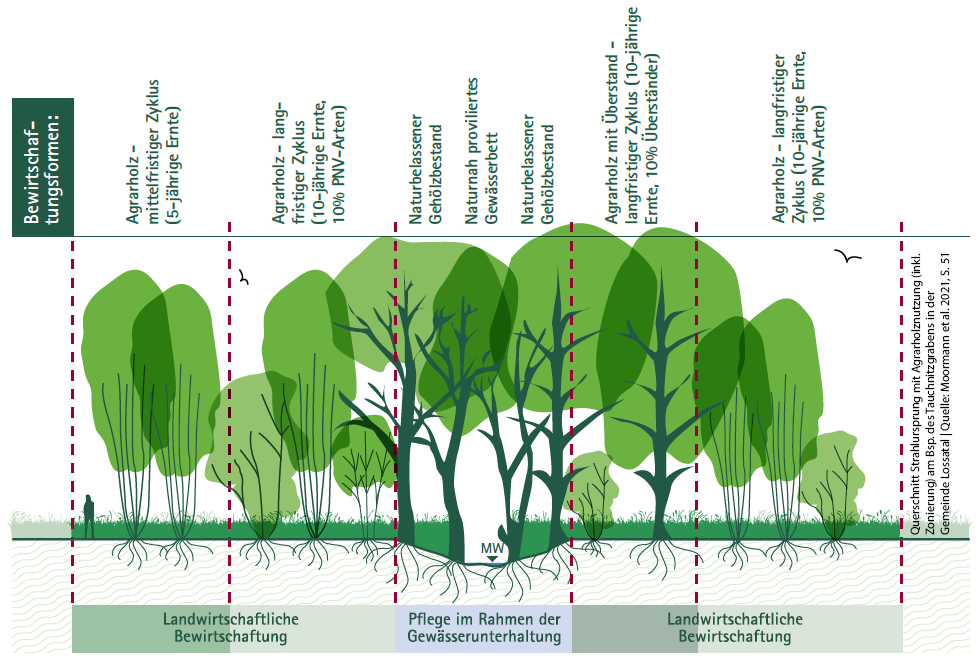
Moormann et al. (2021) propose a well-founded compromise, in which a near-natural system and an adequate wood biomass yield over the years are not mutually exclusive, with a zoned management of agricultural wood along a flowing watercourse. Fig. 1 shows the cross-section of a watercourse. Looking from the middle of the watercourse outwards, extensive use decreases: directly at the water course edge is the strip of naturally grown riparian vegetation, which is maintained within the framework of the applicable water law requirements. The actual agricultural use only begins outside this strip, where a structure-rich plantation of agricultural wood with intermixed species and varieties is favoured. Here, a graded harvesting regime is proposed, which takes place every five to ten years, depending on the growth of the different tree species. Here, the harvesting frequency increases from the water course towards the surrounding landscape - long rotations near the watercourse and medium to short rotations in the outer zones.
In order to be able to implement such environmentally and nature-friendly concepts for the use of agricultural wood along watercourses in the future within the framework of the legal regulations, there is a need for greater negotiation and coordination between agriculture and the nature conservation and water protection authorities. Appropriate structures and fora must be created in the near future.
Regional value creation with agriculturally produced wood
In addition to the environmental benefits, agroforestry structures bring new value-added options for the farmer and his cooperation partners. In a student project at the Chair of Forest Botany at the TU Dresden, recommendations for action for the agroforestry use of riparian strips and economic effects for the Dresden region were developed within the framework of OLGA. In the following, the main possibilities for farmers and municipalities as land owners are depicted.
Create funding incentives and security
The cultivation of agricultural timber represents an additional source of income for farmers and can be cultivated on currently unused, lower-yielding land in less favourable locations, even far away from water bodies. For the highest possible yield, however, higher-yielding sites are more suitable. In order for more agroforestry stands to become visible in the landscape, Saxony still lacks the appropriate funding instruments. This is to change with the introduction of the new Common Agricultural Policy from 2023. According to the Direct Payments Ordinance, the first pillar will subsidise at least two existing strips of woodland or at least 5 or a maximum of 200 woody plants per hectare, but no more than 40% of the agricultural land concerned. The resulting agroforestry systems serve primarily to produce agricultural timber and to add value to fruit and nuts. Within the framework of rural investment development under the EAFRD in the 2nd pillar, investments for the establishment of agroforestry systems can also be funded (Saxon State Office for Environment, Agricultue and Geology (LfULG) 2022, presentation by Lydia Beger about Agroforestry Systems of 07.12.2022).
In addition to lucrative funding incentives, long-term contractual agreements with the purchaser of the wood chips, for example municipalities, industrial companies, municipal and regional energy suppliers, create planning security for the farmer and increase his willingness to cultivate agricultural wood in the longer term.
Regional cooperation for climate-neutral municipalities 2045
The establishment of local heating networks with decentralised woodchip heating systems to supply public buildings in cities and rural areas with renewable energy is one way to become less dependent on the global trade in fossil fuels and to achieve the federal goal of climate neutrality in 2045. Individual municipalities or inter-municipal associations grow agricultural wood on their own land and use the resulting wood biomass for their own energy supply or sell part of it, for example to larger energy companies. For this purpose, investment in decentralised local heating plants based on wood chips is a good option. Despite the initially high investment costs, private households can also reduce their heating costs in the medium to long term by operating woodchip heating systems.
In these cases, a regional association of farms for the joint creation, maintenance and harvesting of agricultural wood structures, including the use of jointly acquired technology, e.g. within the framework of machinery rings, is recommended. To make it more efficient, the cooperation partners could agree on fixed prices for wood biomass/ha with their customers in order to be able to operate more independently of the market and more securely.
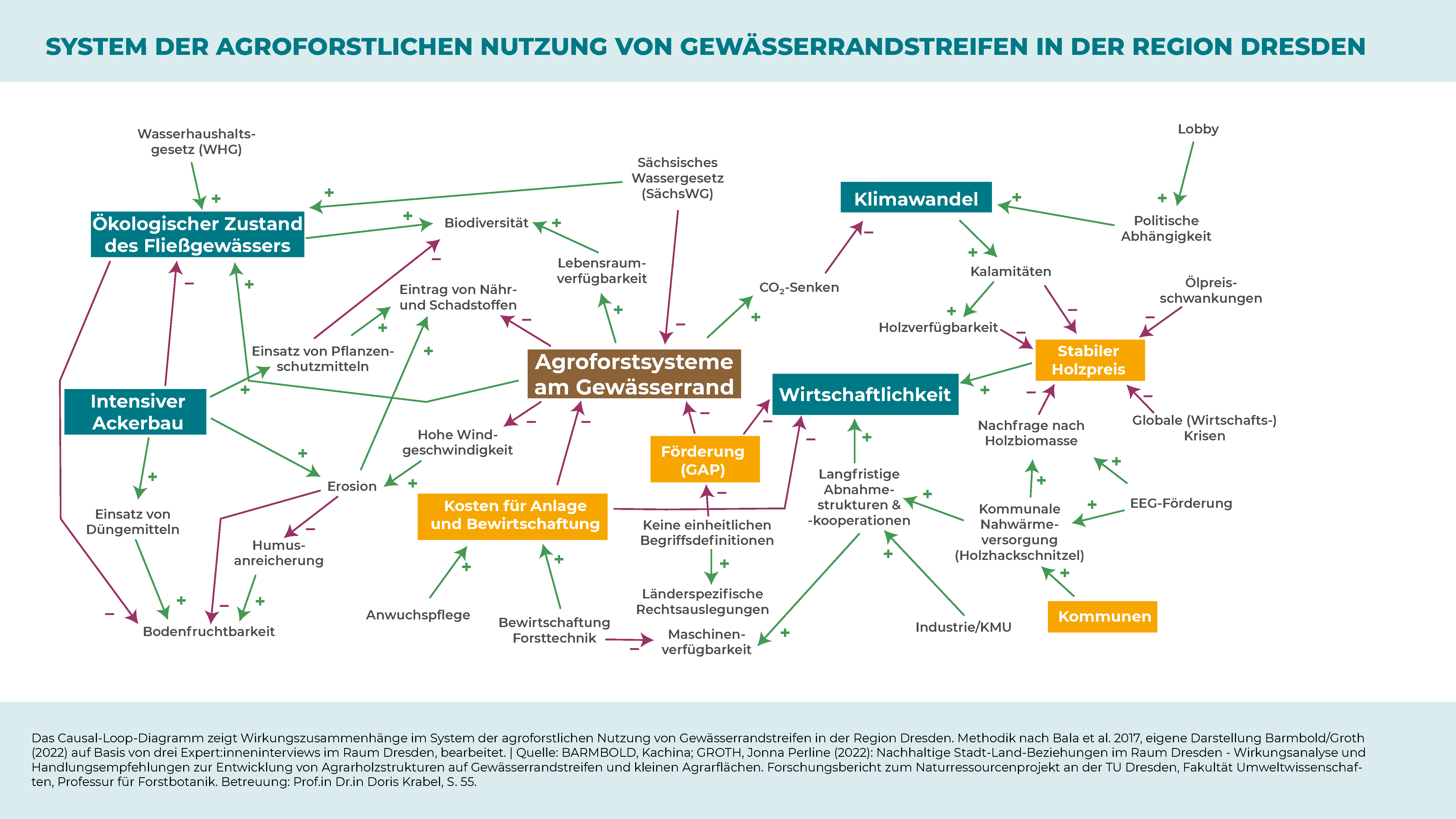
The causal loop diagram in Fig. 2 summarises the complex interactions and interdependencies between the most important system variables that contribute to the economic viability of agroforestry along watercourses, as outlined in this article. In its practical phase 2023-25, the OLGA project will further expand and develop the existing value creation options in the field of agrowood cultivation and use in the Dresden region. In order to primarily reduce the poor image of and reservations about this form of land use, several demonstration areas are planned for both agrowood systems along watercourses and agroforestry systems on arable land. Within the framework of information days and walk-throughs, farmers, authorities and other interested people are to come into exchange directly on the field about the advantages and disadvantages, potentials and challenges in the establishment and management of agroforestry land uses.
Causal loop diagram "Agroforst an Fließgewässern" (German) for download [pdf, 374 kb]
_____________________
Sources:
Barmbold, K.; Groth, J. P. (2022): Nachhaltige Stadt-Land-Beziehungen im Raum Dresden - Wirkungsanalyse und Handlungsempfehlungen zur Entwicklung von Agrarholzstrukturen auf Gewässerrandstreifen und kleinen Agrarflächen. Forschungsbericht zum Naturressourcenprojekt an der TU Dresden, Fakultät Umweltwissenschaften, Professur für Forstbotanik. Dresden
Online verfügbar: https://www.projekt-olga.de/site/assets/files/1314/2022_barmbold_groth_forschungsbericht_agrarholz.pdf
Böhm, C. & Hübner, R. Hrsg. (2020): Bäume als Bereicherung für landwirtschaftliche Flächen: Ein Innovationskonzept für die verstärkte Umsetzung der Agroforstwirtschaft in Deutschland. Cottbus, IG AUFWERTEN
Online verfügbar: https://agroforst-info.de/wp-content/uploads/2020/03/Innovationskonzept-Agroforstwirtschaft.pdf
Sächsisches Landesamt für Umwelt, Landwirtschaft und Geologie (2022): Webinar „Agroforst und dessen Förderung durch die neue GAP“ am 07.12.2022
Moormann, C., König, J., & Marsch, M. (2021): Gewässer in Sachsen – Wege zu einer naturnahen Gewässerentwicklung. Dresden
Online verfügbar: https://publikationen.sachsen.de/bdb/artikel/37730/documents/58253

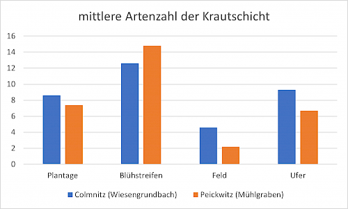
During the evaluations of the vegetation surveys carried out in the OLGA project in 2021, it was confirmed that light in the agricultural wood plantations is the limiting factor for plant growth in the herb layer and that the low light availability in the plantations has a direct impact on the number of species.
On the two study sites at the Wiesengrundbach in Klingenberg-Colmnitz (district of Sächsische Schweiz-Osterzgebirge) and at the Peickwitzer Mühlgraben (district of Oberspreewald-Lausitz), the agroforestry structures were very species-poor. Fewer species could only be found in the utilised arable land, as here only a few herbs can establish themselves next to the cultivated plant due to the regular soil cultivation, among other things. The most species-rich areas at the Wiesengrundbach and at the Peickwitzer Mühlgraben are the flowering strips or the unworked areas between agricultural trees and arable land.
At the Colmnitz site, numerous willow and poplar varieties were planted in 2007. During the analysis of our data, we noticed that the number of species was higher in the poplar area. We can explain this by the lower shading capacity of the poplars compared to the willows. Besides the light factors such as the age of the agroforestry system, the time since the last harvest or the
distance to forest-like structures play a major role for the species composition and forest attachment of the species. The agroforestry system in Colmnitz is located directly next to a small forest and is a few years older than the Peickwitz study site (planted in 2015), which is just 200-450 m away from the nearest forest structure. Therefore, Colmnitz tends to have plants that are better adapted to more intensive shading, such as common carnationwort or common thorn fern. In addition, about 50 % of the herbaceous species within the agroforestry structure in Colmnitz belonged to forest species or field copses, whereas in Peickwitz many species were found that also grow in fields, vineyards and gardens.
In Colmnitz, no endangered species or species rare in the study region could be discovered. In Peickwitz, on the other hand, we documented the meadow bellflower, which is on Brandenburg's list of endangered species, on two plots within the agricultural woods. The low number of rare and protected plant species is not unusual in agricultural wood structures, as light is often crucial for these species and the light intensity decreases with increasing age of the trees.
Tab. 1: The mean weighted ecological indicator values of the study areas and the respective study plots agroforestry system, flower strips, field and bank. The light number describes the occurrence of the plants in relation to the lighting intensity (from 1-low shade plant to 9-full light plant), the temperature number evaluates the occurrence in the respective warmth range (from 1- cold pointer to 9- extreme warmth pointer), the continentality with a range from 1- euoceanic (European Atlantic coast) to 9- eucontinental (Eastern European regions), the moisture number describes the occurrence on the basis of the moisture of the site (1- strong-dry pointer to 12- underwater plant), the reaction number evaluates the occurrence depending on acidic to calcareous soils (1- strong-acid pointer to 9- base and lime pointer) and the nutrient number describes the nitrogen availability in soils (1- extreme low nitrogen pointer to 9- excessive nitrogen pointer).
|
Study area |
Average pointer value | Average weighted pointer value | |||
| Plantation | Flower strip | Field | Shore | ||
|
Colmnitz (Wiesengrund-bach) |
Light number |
5,0 |
7,0 |
6,0 |
5,8 |
| Temperature number |
5,0 |
5,9 |
5,5 |
5,6 |
|
| Continentality |
4,6 |
3,3 |
3,9 |
3,8 |
|
| Moisture number |
4,7 |
5,1 |
5,6 |
5,1 |
|
| Reaction number |
7,1 |
6,2 |
6,2 |
6,7 |
|
| Nutrient value |
7,5 |
6,5 |
7,4 |
7,5 |
|
|
Peickwitz (Mühlgraben) |
Light number |
7,0 |
6,3 |
7,0 |
7,0 |
|
Temperature number |
6,0 |
5,7 |
6,0 |
5,6 |
|
|
Continentality |
3,0 |
3,2 |
2,0 |
3,2 |
|
|
Moisture number |
6,0 |
5,0 |
4,0 |
5,9 |
|
|
Reaction number |
6,0 |
4,8 |
7,0 |
6,1 |
|
|
Nutrient value |
7,9 |
5,9 |
3,0 |
7,1 |
|
In OLGA, agroforestry systems along watercourses at the Peickwitz and Klingenberg-Colmnitz test sites are being studied with regard to their microclimatic effects on the watercourse itself, the soil and the immediate surroundings. In addition to climatic analyses, further analyses are carried out on woody plant physiology, vegetation diversity and biomass. Selected results of last years measurements are presented below.

Fig. 1: Study sites of the measurement campaigns in the OLGA project
Monitoring the microclimate inside and outside the agroforestry system
Initial information on radiant heat shows that the temperature outside the agrowood stand on the farmland can be up to 10°C higher on a warm summer day. The recording of temperature and humidity from June to October 2021 by permanently installed climate sensors on the test sites in Peickwitz and Klingenberg-Colmnitz shows that within the wooded strips there is an equalisation of the daily minima and maxima. This means that, on the one hand, the night temperatures decrease less and, on the other hand, the daily maximum temperatures increase less than outside the area. Fig. 2 illustrates the temperature course within the experimental stands from 28th of June to 4th of July 2021 and, in addition, the course of the temperature measured at the Klettwitz weather station of the German Weather Service located near Peickwitz. The graphs show temperature differences between the stand (Peickwitz agrowood structure) and the open area (DWD Klettwitz weather station).

Fig. 2: Temperature profile at the Peickwitz and Colmnitz test sites and from the Klettwitz weather station from 28th of June to 4th of July 2021
Is there a connection between the spatial structure of the agrowood system and the growth of the trees?
The part of the agrowood plot in Peickwitz planted with the Fritzi Pauley poplar variety was established in 2015 and has a size of approx. 0.43 ha. When selecting the study plot, we ensured that it was as homogeneous as possible and had a low plant failure rate. In addition to phenological characterisation, the trunk diameter and the annual growth of the trees were recorded using a dendrometer. The aim of the study is to determine to what extent the structure of the narrow agricultural wood strip at the Peickwitzer Mühlgraben influences the growth of the trees. The average diameter at breast height (BHD) at the end of the 2021 growing season was 12.92 cm. It is noticeable that the individuals in the second row both at the edge of the field and directly at the watercourse have the highest BHD values. This is probably due to the weaker light competition compared to the inner area of the plot. Fig. 3 shows a typical temperature and dendrometer curve for the Peickwitz test site in the period 17th to 21st of June 2021. As the daily temperature increases, the circumference of the trunk decreases in each case due to the increased transpiration rate. Over the period, an increase in girth is recorded.

Fig. 3: Section of a typical temperature (red) and dendrometer curve for the Peickwitz test site
Determining the biomass growth per hectare with terrestrial laser scanning
For our test site at Peickwitz Mühlgraben, we were interested in how much biomass the poplar variety Fritzi Pauley has produced since 2015 and what the potential biomass production per hectare is for this site. Since no poplars need to be harvested for this estimate, a 3D point cloud of the trial plot with about 70 poplars was created with the terrestrial laser scanner, from which the individual woody plants were cut out using software (Fig. 4). Using the calculated 3D models, the biomass per poplar could be determined and then extrapolated to 1 ha. The advantage of this methodology is that a very accurate estimate of the woody plant volumes can be made even without harvesting. The results show that the biomass is distributed very evenly between the stem (53-41 % of the total volume) and crown segments (47-59 % of the total volume). The tallest poplar in the experimental plot is just over 16 m high, while the smallest is only about 6.50 metres. The latter is in the row with the lowest failures, which shows that competition between the poplars is probably particularly high.
Since spring 2022, new measurements are being taken with the terrestrial laser scanner. In the course of the year, all calculations will be repeated and the results compared. This will provide us with precise statements on the growth of the poplars within the 2021 vegetation period. From the analyses of the biomass growth, it can already be summed up that the agroforestry structure at this site is economically very profitable.
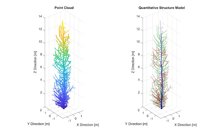
Fig. 4: Point cloud of a segmented poplar hybrid on the Peickwitz experimental plot (left), the three-dimensional quantitative structure model calculated for it (right).
Findings on plant physiology and water balance of selected poplar varieties
So far, the poplar cultivars Max3 (Populus nigra x P. maximowiczii) and Fritzi Pauley (P. trichocarpa) have been compared on the test sites Peickwitz and Klingenberg-Colmnitz. Data were collected on above-ground biomass formation (including leaf and shoot mass, leaf area, shoot length, root-shoot ratio) and root mass and morphology. The comparison of varieties with three irrigation variants each (normal, water level 1/3 and 2/3 pot height) shows in summary that the variety Max3 produces an average of 8.22 g leaf dry mass across all irrigation variants. This is significantly more than the plants of the Fritzi Pauley variety with an average of 5.31 g.
The dry matter between the treatment variants varies less with Fritzi Pauley than with Max3. The latter shows a clear reduction in leaf mass in the irrigation variant 2/3, which indicates less plasticity with regard to the environmental factor "prolonged high groundwater level". The development of the root system as well as the root-shoot ratio indicate how well the plant can penetrate the soil to reach groundwater or react to an oversupply or undersupply of water. The comparison of varieties shows that Max3 forms the longest roots across all diameter classes in the normal variant. Correspondingly, the shortest roots are formed in the variant with groundwater at 2/3 pot height (Fig. 5). Fritzi Pauley forms the longest roots in the 1/3 irrigation variant, reacts to the 2/3 flooding variant similarly to the normally irrigated approach. This result also indicates a variety-specific root-growth reaction and that a water requirement adapted to the individual genotype produces optimal growth performance.
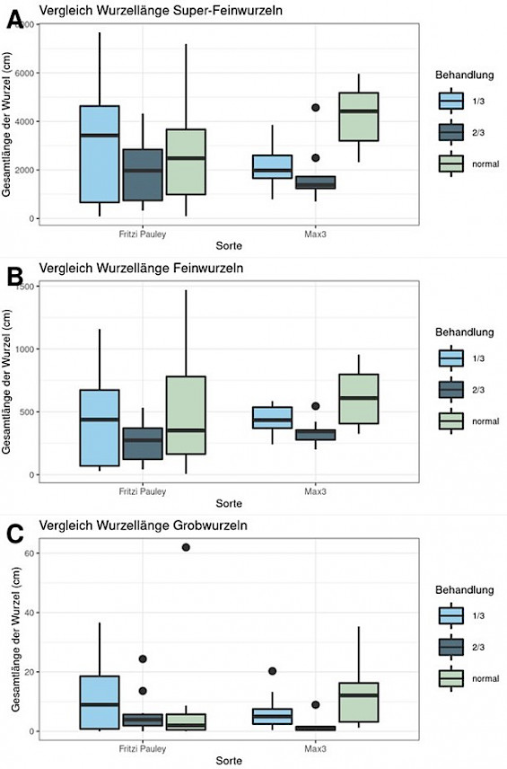
Fig. 5: Variety comparison with regard to total root length, separated according to diameter classes (diameter class superfine=<0.5mm, fine=0.5-2.0mm, coarse=>2.0mm)
Apart from the economic efficiency of the agroforestry system, this result indicates that agroforestry structures should be established with a mixture of varieties whose composition is adapted to the distance from the watercourse. In order to be able to make comparisons, the extensive measurement campaign from 2021 will be continued in 2022. The results will be published here soon.
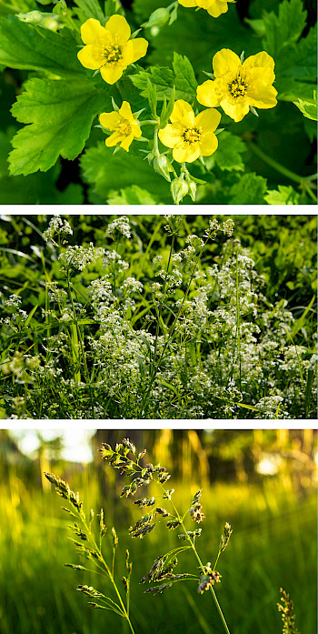
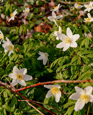
Photos from top to bottom: Animaflora PicsStock, skymoon13, Marco Warm - all stock.adobe.com.
In order to evaluate our study areas at the Peickwitz millrace near Senftenberg (Bandenburg) and at the Wiesengrundbach near Dresden (Saxony) from a nature conservation perspective, vegetation surveys were carried out in the herb layer in early summer 2021. We investigate the influence of the agroforestry plantations on plant diversity and use adjacent reference areas (agricultural areas, marginal, flowering and riparian strips of water bodies) as a comparison. As there is forest in the vicinity of the agroforestry plantations, we extended the study design by five circular survey areas along the transect* agroforestry plantation - agroforestry area - forest and additionally five along the transect agroforestry plantation - agroforestry area/ riparian strip - railway line at the Peickwitz millrace. The aim of the transect analysis is to identify possible dispersal routes of plant species and to find out whether the agricultural wood plantations could be part of a biotope network in the respective landscape context. Railway lines are also relevant for the spread of neophytes.
In total, the species composition and cover was recorded on 55 plots, 25 plots are located at the Wiesengrundbach and 30 plots at the Peickwitz millrace.
In the agricultural woodland plantation at the Wiesengrundbach, a total of 22 species were logged, with common colewort (Geum urbanum) and meadow bluegrass (Poa pratensis) being particularly common and having high cover levels. Almost two thirds of the species are found both in the forest and in the open country.
At the Peickwitz millrace, 19 species could be recorded. Catchweed (Galium aparine) was the most common species with the highest cover percentages. More than half of the species are purely open-land species that occur, for example, in herbaceous vegetation, margins or as field weeds. One third of the species can be found both in the forest and in the open landscape. On the reference areas, the total number of species ranged from 9 (Wiesengrundbach, reference area agricultural area) to 36 species (Peickwitz millrace, field edge).
Further analyses will be carried out in the coming months. We will report on their results in due course.
---
*Transect: Along a transect, a marked straight line, data are recorded at fixed intervals. This method is used when you want to establish a spatial relationship to the object of investigation. This method is often used in ecology (botany and zoology), for field investigations (mapping) and in geology and geoecology.
(Source: https://www.pflanzenforschung.de/de/pflanzenwissen/lexikon-a-z/transekt-10152, accessed on 30.11.2021)
Floods are natural events. The starting point is long-lasting, large-scale continuous rainfall or short, heavy rainfall events. When the resulting water masses become too large, rivers and streams overflow their banks and flood the foreland. These floodplains act as natural retention areas that can absorb and hold back large amounts of water. In this case, the vegetation along the watercourses can have a braking effect on the water masses, delay the flood wave and reduce the runoff peaks.
Within the OLGA project, the Institute of Hydraulic Engineering and Technical Hydromechanics at TU Dresden is investigating the extent to which riparian vegetation (including agroforestry structures) can reduce the flood risk in downstream settlement areas. One study area in OLGA is the renaturalised section of the Wiesengrundbach stream in Klingenberg-Colmnitz in the district of Sächsische Schweiz-Osterzgebirge.
The simulation below shows that the agricultural wood plantation established to the left of the road running from the northwest to the south retains the water only minimally and thus does not really serve as a retention area in this case. The reasons for this are the damming of the water to the right of the road, because the Wiesengrundbach crosses underneath it through a pipe, and the deepening of the stream at the level of the plantation.
https://www.youtube.com/watch?v=_hU6Oae8tAw
Staff members of the Chair of Biodiversity and Nature Conservation at the TU Dresden supervised a student project work within the OLGA project as part of the Master's degree course in Spatial Development and Natural Resource Management, which is carried out in cooperation between the TU Dresden and the Leibniz Institute for Ecological Spatial Development. As part of the work, the area potential for planting agricultural trees in Dresden and the surrounding districts was analysed. In addition to the energetic utilisation of the fast-growing wood, the ecological condition of flowing waters is to be improved in accordance with the EU Water Framework Directive.
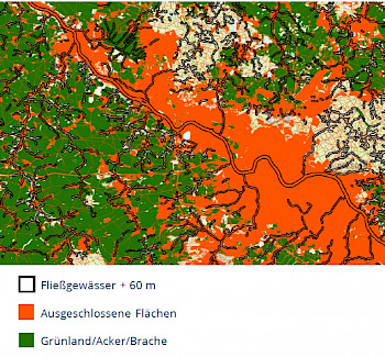
A catalogue of criteria regulating requirements, exclusion areas and legal framework conditions for potential areas of agricultural timber planting served as a starting point:
- Current land use: arable land, grassland, fallow land
- Distance to water bodies: 60 m surrounding
- Distance to settlement and traffic areas: 8 m
- Exclusion: Area natural monuments, core zones of national park and biosphere reserve, legally protected biotopes, floodplains
- Slope: max. 20 %
- Area size: 2-20 ha per agroaric wood plantation

Using data sources from the Saxon State Office for Environment, Agriculture and Geology and the Saxon State Office for Geographic Information and Surveying, the potential areas were determined with the help of the geographic information system ArcGIS Pro.
After the analysis had been carried out, 2,480 areas were considered for the establishment of agroforests, which lie within a radius of 40 km around the city limits of Dresden and fall within the specified area size of 2-20 ha per agroforestry plantation. These have a total area size of 8,951 ha, which corresponds to a share of grassland, arable land and fallow land of 7 %. Most of the potential areas are rather small and reach the minimum size of 2 ha. The average size of all potential areas is 3.6 ha, with the largest area being 17.2 ha. Areas larger than 20 ha are also potentially suitable for planting several agroforestry plantations, the size of each not exceeding 20 ha.
The results of the work provide an initial assessment of possible land uses with agricultural wood in the Dresden region. The catalogue of criteria will be further specified in the further course of the project in order to finally determine the land potential and feasible areas for implementation.
----
HERZIG, Marie, SCHWARZ, Lena (2021): Etablierung von Gehölzen zur Verbesserung des ökologischen Gewässerzustandes - Analyse zum Flächenpotenzial in der Stadt Dresden und umgebenden Landkreisen (GIS-Auswertung). Student work at the TU Dresden, Faculty of Environmental Sciences in the Master's programme in Spatial Development and Natural Resource Management, within the framework of the OLGA project.
In addition to naturally grown riparian woody plants, agricultural woody structures can contribute to shading the watercourse and thus cooling it down. The fall of leaves in autumn can also serve as a food source for microorganisms living in the water body. Plants act against erosion and can reduce pollutant inputs from agriculture into the watercourse. Woody agricultural plantations along watercourses can also contribute to flood protection, as the trees have a retention effect due to their flow resistance and thus slow down flood waves.
So what exactly must these agricultural wood structures be like, i.e. which tree species should be used and how should they be planted so that they have a positive effect on the climate in and around the watercourse, on the soil and on biodiversity? The TU Dresden's science partners have launched a comprehensive measurement campaign at three sites in the Dresden region to answer this question.
Climate and woody plant parameters are the focus of the investigations
Another agricultural wood structure included in the investigations is located at the Wiesengrundbach in Klingenberg-Colmnitz near the Tharandt Forest. Here, the surveys are in the area of flowing waters, as well as at another site at a renaturalised watercourse section of the Mortelbach near Waldheim (LK Mittelsachsen). The Chair of Hydraulic Engineering collects information on the hydraulics of watercourses, the microclimate of watercourses and the macrozoobenthos (benthic invertebrate fauna) and investigates the correlation between these parameters.
In addition to the woody plant physiological, climatic and hydraulic measurements, the Chair of Biodiversity and Nature Conservation is supplementing the investigations with analyses of the woody plant structure and, the position of the trees and the flowing water in the space using high-resolution, terrestrial 3D laser scanning. Based on the laser scanning data, a digital terrain model of the study areas is created. Furthermore, the soil composition and the vegetation composition in the plantation itself and in the surrounding agricultural areas will be investigated and the diaspora bank analysed on the basis of soil samples.
The TU Dresden's measurement campaign will run this year and next. It is intended to provide information on the multifunctional and biodiverse implementation of an agricultural wood structure.